
Whatever your fitness level, scaling these mystical mountains in Asia – from Bhutan to Sichuan – is certain take your breath away.
Asia is home to at least 190 of the 200 tallest mountains in the world. For an amateur like me, the idea of climbing any of these behemoths is pie in the sky. Having scaled some of the continent’s smaller peaks, however, I’ve noticed a recurring theme: the great spiritual and cultural significance they hold in their respective lands.
Here are the four mystical mountains I’ve hiked in Asia – and my experiences reaching their sacred summits.
Bhutan: Paro Taktsang pilgrimage
Those who’ve read the third and final instalment of my Bhutan travelogue will be familiar with Paro Taktsang – or ‘Tiger’s Nest’, as it’s known in English. What I didn’t explain in that post is the origin of the monastery and its name.
According to local legend, Buddhist master Padmasambhava, also known as ‘Guru Rinpoche’, reached the site on the back of a flying tigress in the 8th century. There, he meditated in one of several caves, setting an example that many more eminent Buddhist monks would later follow.
In the 17th century, Bhutan’s leader Gyalse Tenzin Rabgye built Paro Taktsang around the sacred caves, and the monastery endured there until 1998 – when a fire destroyed it almost entirely. Restoration works, concluding in 2005, brought Tiger’s Nest back to its former glory.

This, admittedly, is an abridged version of a story that merges mythology with historical fact, but it nonetheless provides an idea of the site’s importance.

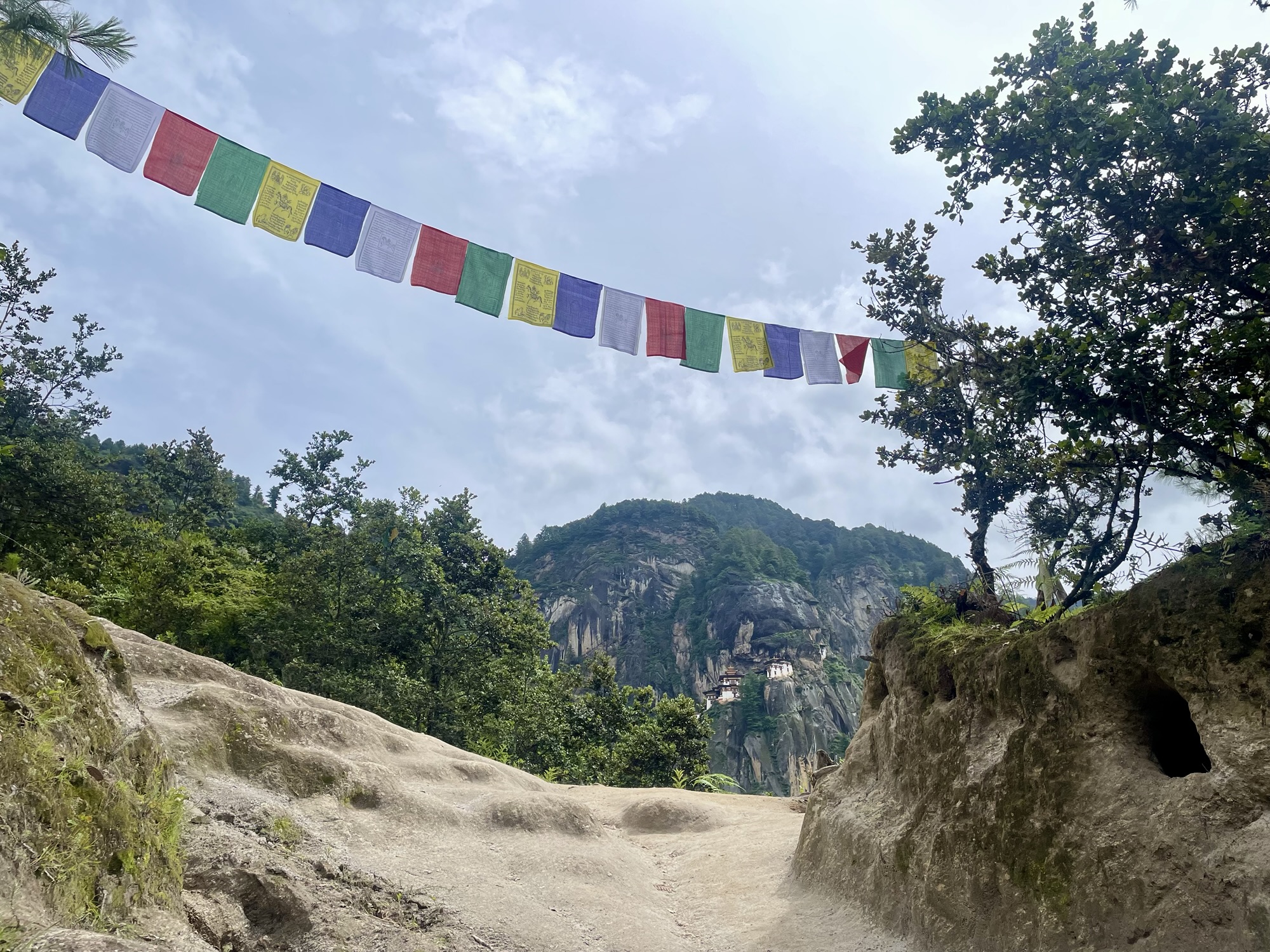
While Paro Taktsang isn’t found at the summit of a mountain, it does represent the end point of a hike – a hike that is so profoundly spiritual it feels more like a pilgrimage.
It took us around an hour and a half, including several photo stops, to reach the monastery from the car park at the foot of the mountain. Although short, the route is steep, involving an elevation gain of approximately 500 metres and culminating in an exhausting climb up a long flight of stairs.

Even if the hike doesn’t leave you breathless, the sweeping views of Paro Valley – and the mystical ambience inside monastery – surely will.

A well-earned cup of green tea on the way down from Paro Taktsang.
A series of shrines just off the path to the monastery.

Guided tours are recommended in Bhutan, and the hike to Tiger’s Nest features on most itineraries, with admission to the monastery included in the price. We booked our tour with the excellent Third Rock Adventures.
Nepal: Pokhara to Pumdikot Shiva Statue
Just days after returning from Bhutan to Kathmandu, Nepal, we headed west to Pokhara.
Known as a gateway to the Annapurna Circuit trekking trail, for us, Pokhara proved an ideal location in which to wind down after a non-stop few weeks in India, Bhutan, and Kathmandu. Nepal’s second city, situated on the serene shores of Phewa Lake, is far more laidback than the capital (which is, chaos notwithstanding, one of my favourite places on Earth).
While we didn’t have the time, energy, or mountaineering experience for an Annapurna trek, we had just enough left in our tanks to reach the Pumdikot Shiva Statue overlooking Pokhara Valley.

The hike from the base of the hill to the statue is more gentle than the climb to Paro Taktsang but takes around twice as long, reaching an altitude of around 1,500 metres above sea level – roughly 700 m higher than the city of Pokhara. It wasn’t exactly challenging, but the mid-summer heat and humidity made it uncomfortable at times. Thankfully, our significant loss of moisture wasn’t in vain: the views – not only at the summit but all the way along the ambling route – were majestic.

Before reaching Shiva, we stopped by the World Peace Pagoda – or Shanti Stupa – which was well worth the detour. The short distance from this Buddhist landmark to a statue of a Hindu deity reflects how the Dharmic religions peacefully coexist in Nepal. In fact, the overlap between Buddhism and Hinduism is particularly strong in this part of South Asia, with local followers of the two belief systems happily sharing temples and participating in each other’s festivals – a refreshingly harmonious relationship between major religions.
A Buddha statue at Pokhara’s World Peace Pagoda.


The Pumdikot Shiva Statue.
The hike to the Pumdikot Shiva Statue was further enhanced by our befriending a local dog, whom we called ‘Lassi’ (a play on the name of the Rough Collie in the Lassie books and films, and South Asia’s favourite yoghurt drink).
Just like her human compatriots, Lassi made us feel welcome in her domain, kindly guiding us to our destination – and even protecting us from some grumpy goats along the way.
‘Lassi’ faces off against some grumpy goats blocking our path.

Jeju Island, South Korea: Hallasan hike
It was a year to the day after our Paro Taktsang pilgrimage that my wife Maria and I hiked South Korea’s tallest mountain, Hallasan (Mount Halla), on the subtropical island of Jeju south of the mainland.
Standing just shy of 1,950 metres above sea level, Hallasan is a shield volcano whose eruptions contributed to Jeju’s creation. In local shamanistic folklore, the giant goddess Seolmundae Halmang (Grandmother/Goddess Seolmundae) formed the mountain – and indeed the entirety of Jeju-do (Jeju Island) – by dropping sand she had carried in her skirt into the sea.
There are many more tales surrounding Hallasan’s origins and its significance to the people of Jeju; the mythology and factual history of the mountain and the island it helped to create are fascinating. However, since I’m no authority on the subject, I’d point you towards the Lisa See novel The Island of Sea Women if you want to learn more. While the plot focuses on the troubled friendship between two of Jeju’s haenyeo (skilled female divers who gather seafood from local waters), See beautifully weaves in local folk beliefs and historical events – including some relating specifically to Mount Halla. Maria and I read the book before our trip, and it whetted our appetite for exploring Jeju and Hallasan.

On our third day on the island, we arose before dawn and drove from our hotel to a car park at the entrance to the Seongpanak Trail. The early start was necessary as we had to reach Jindallaebat Shelter (approximately 1,500 m above sea level and 7.3 kilometres into the 9.5-kilometre hiking route) before 12:30 to ensure we’d be back on flat land before sunset.
As it turned out, we could’ve spent longer in bed. The round-trip took us about seven hours including stops – in line with information we’d found online – and we were back at our car not long after 14:00.

I took this photo at 12:20 – on our way down from the summit. We could’ve had an extra hour or two in bed…
The Seongpanak Trail is the longest of seven routes to Hallasan’s summit, but that makes the ascent relatively gentle. Somewhat complicating what is otherwise a fairly straightforward hike is the uneven rocky path, which was slippery in the mountain mist.
The misty trail to Hallasan’s summit.


Two large-billed crows in the mountain mist. One points the way to the summit, the other to the nearest shelter.
The humid, foggy conditions that added an element of treachery to our descent had also completely obscured our view of Baengnokdam, the crater lake at the summit. Still, standing at South Korea’s highest point is reward enough in itself, so any disappointment was short lived.

Baengnokdam, which translates to ‘white deer lake’, derives its name from legends about deer that inhabit the area around the mountain summit. Deer – albeit not the white kind – are a common sight on Hallasan. We were lucky enough to spot a few specimens of the Jeju roe subspecies, including the buck pictured below, which – in this photo at least – reminds me of the Forest Spirit from Studio Ghibli’s Princess Mononoke.
A Jeju roebuck gazes back at us from among the trees near the base of Mount Halla.

To anyone visiting Jeju-do who is physically capable of making the hike, I’d thoroughly recommend scaling Hallasan. As the highest point in South Korea and the most culturally significant location on the island, it has a mystique all its own. Just make sure to start early, wear shoes with good grip, and take plenty of water and snacks – as you won’t find many refreshments on the trail.
Sichuan, China: magical Mount Emei
Maria and I hiked Emeishan (Mount Emei) in China’s Sichuan Province in April 2025 while living in nearby Chengdu. The mountain is one of Sichuan’s most famous attractions, and scaling it almost felt like a rite of passage – something we simply had to do during our time in China.

Reaching approximately 3,100 metres above sea level, Emei is the tallest of China’s Four Sacred Buddhist Mountains. It’s also where, in the 1st century, the nation’s first Buddhist temple was established. Many more temples have made Emeishan their home since then, contributing to the site’s importance in Chinese Buddhism – as well as to its significant tourist appeal.

A dog sleeps peacefully outside the Hall of the Heavenly Kings at Hongchunping Temple, roughly halfway up Emeishan.
To reach the mountain, we took a train from Chengdu South to Emeishan Railway Station and caught a local bus from there to Baoguo Temple, which sits at an altitude of around 550 m and serves as the main starting point for the hike. Several of the temples along the route offer bed and board to weary hikers, but we’d booked a hotel in Leidongping – roughly three-quarters of the way to the summit – to ensure we had a place to stay before our final ascent the next morning.
Due to a navigational blunder, we’d arrived at a bus station from which visitors can reach Leidongping by road and complete their journey from there via cable car. By the time we found the hiking entrance at Baoguo Temple, the troubling eventuality of not making it to our hotel before sunset had begun to feel very real – so we set off at a blistering pace.
This was our second mistake. The route to the summit is essentially one very long, often very steep staircase. With my legs seizing up more than once, I found myself questioning our decision to undertake this extremely strenuous hike in the first place.
Our third misstep was not paying the nominal fee for a pair of bamboo hiking poles at one of the shops near the foot of Emeishan. Stalls selling climbing equipment, snacks, and souvenirs are found all the way up the mountain. The higher the altitude, the more the vendors charge.
Feeling uncharacteristically cynical due to fatigue, I initially thought this was a way of profiting from climbers’ mounting exhaustion – and refused to pay over the odds for walking sticks that would’ve certainly lessened my suffering. In truth, the elevation-linked inflation simply reflects the increased complexity of having goods transported further up the mountain. Don’t make the same mistake as we did; bring your own poles or buy them at the base.

Hiking sticks may also come in handy to deter the Tibetan macaques that populate the mid-point of Emeishan, where they lie in wait to steal snacks from unsuspecting tourists.
Our first encounter with the mountain monkeys set us on edge. We saw a female macaque sitting on a railing post, appearing harmless enough as we stopped to take photos. Then, as we passed, she let out a series of hoots, and a younger, more fearsome-looking male emerged from the bushes followed by a couple of diminutive juveniles. The alpha approached us directly, sizing us up and no doubt looking for something edible to pinch. Since our hands were empty, we got off lightly. Yet this seemed like a sophisticated ambush system, and whenever we encountered macaques from that point on, we ignored the pangs of protest from our faltering thighs until safely out of sight. By making a considerable portion of our hike feel like running the gauntlet, the mischievous monkeys proved rather effective cheerleaders.
A female Tibetan macaque keeps an eye out for any snacks its troop can pinch from unsuspecting tourists.

Despite our leaden legs and the litany of rookie errors we’d made, we reached Leidongping, unscathed, in around eight hours. There, we had dinner with a young couple from Chongqing we’d met along the way and who happened to be staying at the same hotel as us. After the meal and before settling down for a much-needed rest, we went for a short walk to take in the breathtaking views.

The next morning, fuelled by a cobbled-together breakfast of snacks we’d managed to smuggle past the simian sentinels, we began the final ascent to Emeishan’s ‘Golden Summit’. This part of the trail is significantly shorter than the way up to Leidongping, so we weren’t tempted by the cable car option. We took the picturesque, monkey-free hike at a leisurely pace, reaching the summit in roughly two hours.

A misty gorge viewed from near Leidongping, Mount Emei.
The destination, it turned out, was worthy of the journey.
Greeting hikers at the top of Emeishan’s final flight of stairs is the Ten-faced Puxian Bodhisattva stupa – a 48-metre golden monument comprising a ten-headed bodhisattva (enlightened being) seated upon four elephants, all anchored to an ornate central plinth. The Huazang Temple complex provides a magnificent backdrop to the stupa, while a ‘sea of clouds’ encircles the entire summit, stretching all the way to the distant mountains.
The Ten-Faced Puxian Bodhisattva behind Huazang Temple at Mount Emei’s Golden Summit.


Buddhists circumambulate the Ten-Faced Puxian Bodhisattva in prayer.
Although demanding, scaling Emeishan is an unforgettable experience that I highly recommend to anyone visiting Sichuan. Even if you’re not up for the physical challenge, the summit is easily accessible thanks to the buses and cable cars that run at frequent intervals. And if you decide to rely on your own two legs, just don’t make the same mistakes as us…
For more information on any of the hikes covered in this article, subscribe (if you haven’t already) using the bar at the top of the page and comment below.
Share your thoughts: