
In the first instalment of this three-part New Zealand travelogue, I looked back on my experiences on New Zealand’s lush North Island in 2019. In part two, I recall my journey through the dramatic South Island – from Picton to Milford Sound via Christchurch and Dunedin.
From picturesque Picton to resilient Christchurch
After departing Wellington on the Interislander ferry, we crossed the Cook Strait, which separates the North from the South Island. We then meandered through the arms and inlets of the Tory Channel and Queen Charlotte Sound.

Our destination was the seaside town of Picton: the idyllic gateway to our South Island adventure. We arrived in the early evening and took in the glorious views of Picton Harbour and the surrounding hills before retiring for the night.

One of our first impressions of Picton after disembarking the ferry.
Looking out over Picton Harbour.

While our stay in Picton was brief, the town’s beauty set the scene for the journey to come. The next morning, we got back on the road bound for Christchurch, the South Island’s largest city.
The long drive from Picton to Christchurch perfectly demonstrated the diversity of New Zealand’s South Island – or ‘Te Waipounamu’ in Māori.
Shortly after leaving Picton, we crossed the Para Wetland, where the sun-bleached skeletons of invasive willow trees – poisoned to make way for native flora – provided a haunting foreground to an otherwise verdant backdrop.
Our route then took us through the picturesque Marlborough vineyards. Here, orderly rows of grapevines (an introduced species deemed worthy of life) stand in stark contrast to the ghostly willows of Para Swamp, carpeting the plains and stretching towards the green, rolling hills.

The dead willows of Para Wetland.
A (very much live) vineyard in Marlborough, New Zealand’s South Island.

Next, we passed the expansive salt ponds of Lake Grassmere before skirting the rugged Canterbury coastline and stopping for coffee at Kekerengu, where driftwood art gives dead trees new life. Later, from our vantage point on the coach, we spotted fur seals on the rocky shore.

Lake Grassmere Saltworks.
Driftwood art on Kekerengu Beach.


Fur seals on the rocks at Ohau Point, pictured from the coach.
Continuing south along the coast, we made our next stops on the Kaikōura Peninsula and Kaikōura Beach, which both offer stunning views of the mountain range that shares their name.
Kaikōura Ranges from Point Kean on the Kaikōura Peninsula.


The same mountains as viewed from Kaikōura Beach.
The road from Kaikōura took us inland through the Hundalee Hills and down onto the Canterbury Plains. A couple of hours later, we reached Christchurch, where we spent the night.
In 2011, an earthquake struck just a few kilometres south-east of Christchurch Central Business District, taking 185 lives and leading to the demolition of 80% of the CBD. When we visited in 2019, regeneration was well under way. However, the combination of ultra-modern buildings and empty plots seemed incongruent with Christchurch’s heritage as the first city in New Zealand by Royal Charter – a place once renowned for its Gothic Revival architecture.
We found Christ Church Cathedral, the city’s most iconic landmark, still obscured by construction hoarding. The spireless shell stood as a testament to both a rich history and the massive devastation of 2011 – a reminder of the irresistible geological forces that created New Zealand but can so easily reduce its human-made monuments to rubble.
The spireless Christ Church Cathedral peeks out from behind the hoarding.

Yet Christchurch’s redevelopment also illustrates the resilience of its people. Abundant street art and greenery fill gaps left by the destruction, and the city today is less a relic of the British Empire than it is a reflection of modern and indigenous Aotearoa.

Brandon Warrell’s Rise from the Rubble, depicting the native kōwhai tree and tauhou bird as symbols of Christchurch’s rebirth.
Avon River Precinct – Te Papa Ōtākaro – a Māori-co-designed area that reconnects Christchurch inhabitants with nature.

On down to Dunedin
We departed Christchurch the following afternoon, traversing the patchwork landscape of the Canterbury Plains as we made our way south-west towards the Southern Alps.

Our first stop was at the stone-hewn Church of the Good Shepherd, where we savoured the cyan serenity of Lake Tekapo and the snowy peaks beyond.
Lake Tekapo as seen from inside the church. Views like this could almost make me a believer.


A shoreside vista of Lake Tekapo.
Following a short walk along the shore, we returned to the coach and reached our second stop, Lake Pukaki, soon after. Like its neighbour Tekapo, Pukaki derives its cloudy turquoise hue from ‘rock flour’ – a fine dust created by alpine glaciers grinding against the bedrock. The raw and rugged splendour of the twin lakes and their surroundings felt worlds apart from the softer, more manicured charm of the nearby Canterbury Plains.

That night, we stayed in the small town of Ōmārama at the southern edge of the Mackenzie Basin, setting off for Dunedin, Te Waipounamu’s second-most populous city, the following morning. Although our early departure deprived us of the chance to visit the famous Ōmārama Clay Cliffs, it also presented us with a quintessentially Kiwi spectacle: a merino sheep stock muster blocking a portion of a major state highway.
Morning rush hour in Ōmārama: a merino sheep stock muster forms a traffic baa-rrier on State Highway 8.

Bypassing the woolly roadblock, we headed to our first stop for the day: Benmore Power Station. This functional landmark lies on Lake Benmore, Aotearoa’s biggest manufactured body of water, and is home to the country’s largest earth dam. While the hydroelectric infrastructure itself is hardly eye-catching, it makes for an interesting juxtaposition, its grey utilitarianism set against nature’s green-and-blue spontaneity.

Benmore Power Station, Canterbury.
Back on the road to Dunedin, we made a brief stop at quirky Ōamaru, whose well-preserved Victorian architecture provided the perfect canvas for its transformation into the ‘steampunk capital of the world’.
The historic Woolstore (left) and Criterion Hotel in Ōamaru’s Victorian Precinct.


Ōamaru’s Steampunk HQ.
A skull wearing steampunk goggles – part of an art installation at Steampunk HQ.

Having spent 30 minutes or so exploring Ōamaru’s faux-industrial installations, we carried on down the coast to Dunedin, pausing to behold the equally curious Moeraki Boulders. These otherworldly geological formations – ‘septarian concretions’ lying half buried in the sands of Moeraki Beach – are reminiscent of giant dinosaur eggs partly exposed by time and the power of nature.

Septarian concretions ’emerging’ from the sands of Moeraki Beach.
A fully unearthed boulder whose spherical form and shattered surface recall the unfinished second Death Star from Star Wars.

Bowled over by the boulders, we clambered back on the coach and were soon in Dunedin.
Whereas the 2011 earthquake and subsequent ‘rise from the rubble’ inevitably loosened Christchurch’s colonial ties to England, Dunedin, by contrast, still wears its Scots heritage on its sleeve. The city is even considered the ‘Edinburgh of the South’ – an apt label given ‘Dunedin’ is the anglicised form of ‘Dùn Èideann’, the Gaelic name for the Scottish capital.
Fittingly, the first major landmark we visited in Dunedin was the First Church of Otago – a Gothic Revival masterpiece designed by Scotland-born architect Robert Lawson.

First Church of Otago, Dunedin.
Just minutes from the church is Dunedin Railway Station – a must-visit even if you don’t have a train to catch. Designed by George Troup, a London-born architect who learnt his trade in – you guessed it – Edinburgh, this magnificent Flemish Renaissance ‘Gingerbread House’ is thought to be New Zealand’s most photographed building.
A sign outside the station points to Dunedin’s twin cities, including its namesake, Edinburgh – just 18,869 km away.

The next stop on our unguided stroll around central Dunedin was the University of Otago Clocktower Building. Despite bearing striking similarities to Troup’s Gingerbread House, the heart of New Zealand’s oldest university is in fact the work of English architect Maxwell Bury. Inspired by the main Gothic Revival complex of Glasgow University in Scotland, Bury designed the Clocktower Building’s initial blueprint, with his compatriot Edmund Anscombe later completing major extensions.

University of Otago Clocktower Building, Dunedin.
From the university, we headed to Dunedin’s core, The Octagon – an eight-sided plaza home to St Paul’s Cathedral and the Town Hall, another of Lawson’s grand designs. Unfortunately, our plan to visit the city’s Botanic Garden had fallen foul of an indefinite, and all-too-appropriate, rain check…
The Town Hall and St Paul’s Cathedral on a drizzly Dunedin afternoon – a scene reminiscent of urban Scotland.

Sounds like a fjord
The weather had markedly improved by the time we resumed our journey the next day, bathing the green pastures and snow-capped mountains of the Southland Region in brilliant sunshine. Yet if the westward route was picturesque, it did little to prepare us for the sheer scale and beauty of Fiordland.

Before setting off for New Zealand’s biggest National Park, we spent the night near the shores of its most voluminous lake. The tranquillity of Te Anau – both the lake and the town that took its name – belies the untamed majesty of the neighbouring fiords.

The Murchison Mountains brood beyond the sullen shores of Lake Te Anau.
Faith, a 1935 motor yacht built on Scotland’s River Clyde, moored on the lake.

We awoke early the next morning to begin what would prove the most memorable day of our entire New Zealand experience.

Golden light and a subtle rainbow adorn the morning skies over Te Anau – perhaps hinting at the wonder of the day to come.
As we left Te Anau behind, the scenery swiftly shifted from the delicate to the dramatic. Our route took us into the heart of the Southern Alps via the Eglinton Valley – a glacial corridor that served as our first stop for the day. Carpeted in tussock and flanked by jagged peaks, this iconic location represented the Misty Mountains of Middle-earth in Peter Jackson’s The Lord of the Rings: The Fellowship of the Ring adaptation.

Pressed up against the beech forest at the eastern boundary of the Eglinton Flats are the aptly named Mirror Lakes – known for reflecting the Earl Range opposite in crystal-clear detail. Alas, the wet and overcast conditions revealed only a partial reflection on that late-October morning – but the scene was nonetheless captivating.
The Mirror Lakes are a sight to behold even when they’re not entirely living up to their name.

From Mirror Lakes, we proceeded north, trading the grassy flats of Eglinton Valley for the ice-clad immensity of the deep Alps. We passed roaring waterfalls and soaring peaks en route to the Homer Tunnel, which transects the Darran Mountains in its steep descent towards Milford Sound.

Falls Creek/Christie Falls, just off the Milford Road.
The Darran Mountains pictured from the coach shortly before we began our descent through the Homer Tunnel.


A fine dusting of snow reflects the safety lights above, helping to illuminate the otherwise dingy tunnel.
As we emerged from the dimness of the tunnel, it took our eyes a moment to adjust to the grey-blue light of the Cleddau Valley. Minutes later, we stopped to take in yet another famous sight on the Milford Road: The Chasm.
At this narrow section of the Cleddau River, millennia of abrasive action have sculpted the opposing rock faces into a glistening gorge of smooth yet angular geometry. The Chasm lies nestled in the temperate rainforest that fills the valley, itself enclosed by towering massifs. If the unusual geology and awe-inspiring vistas aren’t reason enough to stop by, visitors to the site frequently encounter kea, the world’s only alpine parrot.

These cheeky New Zealand natives show no fear of humans. On the contrary, the ever-curious kea gather at scenic spots throughout the Southern Alps to interact with tourists and – more to the point – their belongings. They have a particular penchant for rubber, which they pluck and peel with their sharp beaks as a way to flex their equally sharp brains.
Looking down on The Chasm. From this vantage point, the roar of the water was deafening.


The Cleddau River, whose raw energy sculpted The Chasm.
A curious kea at The Chasm car park.


A watchful kea perched atop a tour van in the shadow of Mount Tutoko.
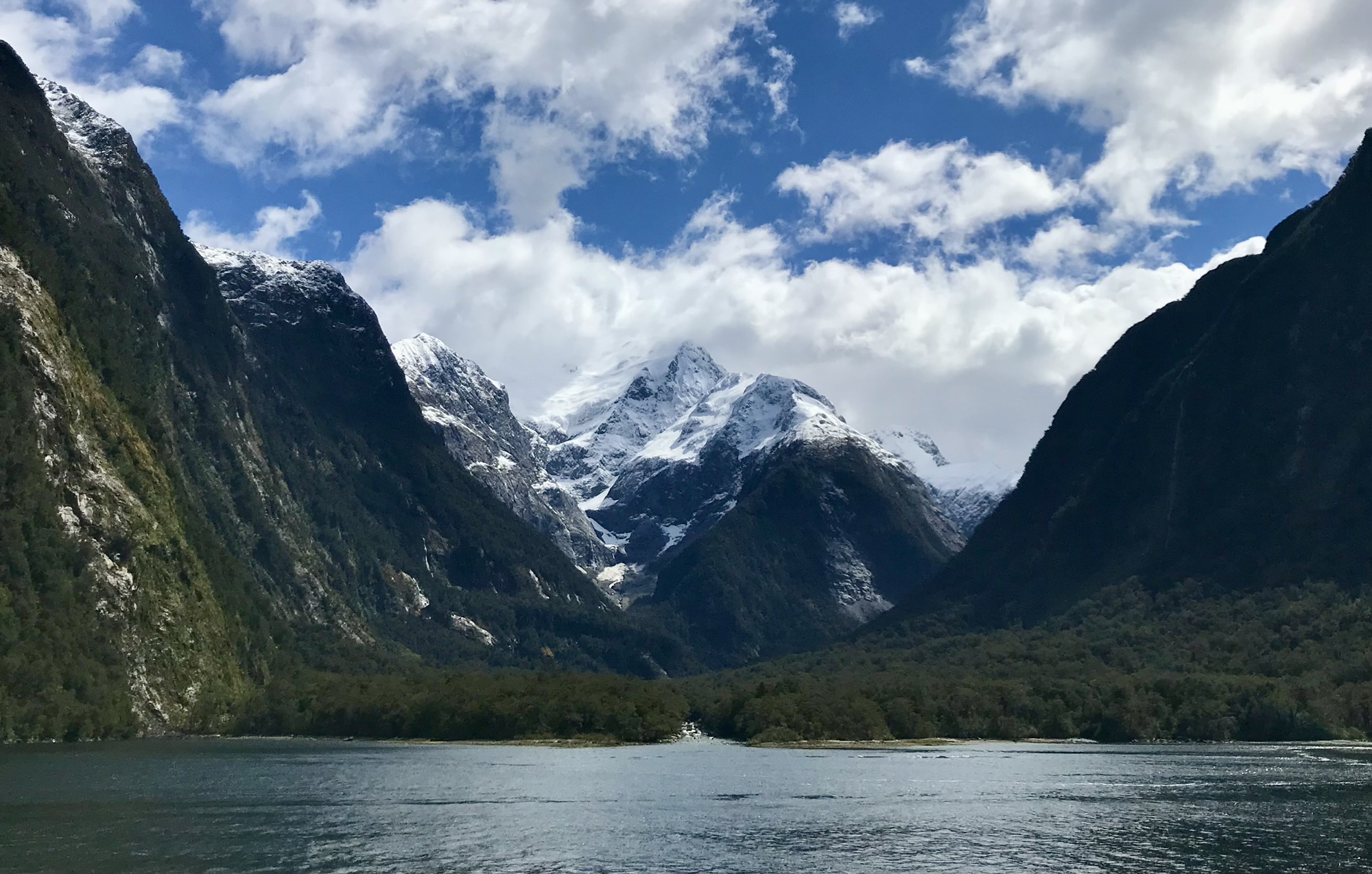
We gazed for a while at the sublime scenery in the company of the clever kea before resuming our descent towards Milford Sound. This glacially carved monument is not in fact a ‘sound’ but a ‘fiord’ – the most iconic of the Fiordland region and arguably Aotearoa’s premier tourist destination.
For anyone interested in the etymology, ‘fiord’ is the anglicised spelling of fjord. While the rest of the Anglosphere has adopted the Norwegian standard due to the landform’s overwhelming association with the Scandinavian country, New Zealand – as proud owner of its own remarkable fiords – retains the variant introduced centuries ago by the Brits.
Whether you refer to it as a ‘sound’, a ‘fiord’, or a ‘fjord’, the original custodians of this natural marvel – the Māori – call it ‘Piopiotahi’. English novelist Rudyard Kipling declared it the eighth wonder of the world when he visited in the 1890s.
It’s quite the privilege, then, to witness such geological grandeur first hand, from a proximity only a fiord cruise allows.

By this point, the weather was impeccable, with the bright blue skies and wispy white clouds playing off the icy summits and accentuating the deeper tones of the water and forested inclines. The rain that previously obscured the Mirror Lakes’ reflection of the Earl Range had moved on from Milford Sound before our arrival, but the memory of its visit lingered as transient waterfalls flowing from the mountainsides.
Milford Sound’s semi-temporary Fairy Falls below a shrouded peak.

Given Fiordland is one of the wettest regions on Earth, many of its ephemeral falls are actually present more often than not. Our boat approached a pair of these semi-temporary ribbons of rainwater, Fairy Falls, allowing us to experience what the locals have coined the ‘glacial facial’.
Compared to Milford Sound’s only major permanent cascades, Stirling and Lady Bowen, the Fairy Falls are but a trickle. We felt Stirling’s full force when the ferry navigated into its significant spray zone.

The powerful and permanent Stirling Falls.
The majestic Lady Bowen Falls.

Dampened and awestruck by the power of Milford Sound, we returned to dry land and boarded the coach heading towards Queenstown. ‘Dry’ doesn’t quite describe the conditions that greeted us at The Divide, where we paused to admire the views. The snow that covered the mountaintops had now begun to fall below the treeline, adding to the sparse piles of white slush already scattered across the valley floor. This is a region notorious for its changeable weather, after all.

Mount Christina stands proud behind the silver beech forest as a light sprinkling of snow reaches the valley floor.
Later that day, our thirteenth in New Zealand and fifth on the South Island, we arrived in Queenstown…
Read about our experiences in the remarkable Queenstown, as well as the grand finale to our New Zealand tour, in the third and final instalment – ‘The South Island’s wild west’.

Share your thoughts: